100% coverage and homogeneity of mapping data.

Non-stop maintenance and up-to-date map data.

Independent and customizable digital map platform.

Connectivity with other location databases and layers.

2 Topographic map

Navigational map

The navigational map platform offers 100% coverage of the road-network in Slovenia and it is the most current location-based database in the region. Additionally, it offers API’s for routing from point A to point B and searching for places. The platform due to it’s independent nature can also be used as a base for all kind of different analysis, planning, visualizations, and calculations.

The digital database is comprised of many different layers such as roads with navigational attributes, railways and other public transport lines, water network, land usage, and layers for point data (shopping malls, parking spaces, gas stations, house numbers, etc.). The customization and connectivity of these layers, within the mapping platform enable a broad range of services and applicability for our clients.

Topographic map

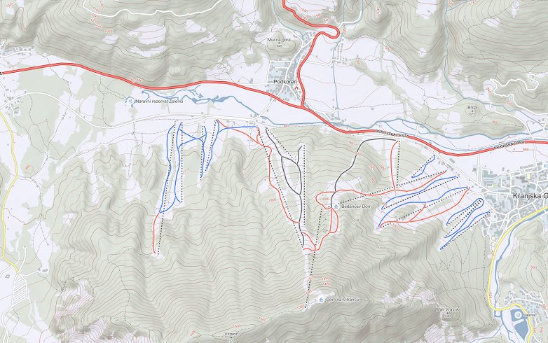
Topographic map is an upgrade of the navigational map and it is a perfect platform for outdoor activities location-based data. It includes data such as elevation profiles, contour lines, hiking paths, biking paths, tourist roads, peak names, marked mountain cabins and other points of interest. All trails contain elevation profiles that help a person navigate in nature. As a platform it allows completely new and exciting experiences in already know as well as less known trails and locations.

Google
Googlovi zemljevidi imajo kot osnovo za svoje podatke Monolitov zemljevid Slovenije, ki ga redno nadgrajujejo z različnimi lokacijami kot so gostinski in namestitveni objekti, naravne in kulturne znamenitosti, bencinske črpalke in mnogi drugi poslovni subjekti.
Sašo PerušCASE STUDY
At HOFER we put quality first, which includes the process of picking our business partners, therefore we decided to work with Monolit. They provide quality solutions, which they pair up with professionalism and kindness.
Elektro Gorenjska
V Elektru Gorenjska uporabljajo Monolitovo kartografsko podlago za načrtovanje in vodenje evidence eletro omrežja na njihovem območju.

What is the Maps platform?

The maps platform is meant for companies with scattered locations of assets, construction companies, investors, distributors, and all those companies that need a quick access to up-to-date location-based data due to the size and nature of their activities.

Maps can be used for all kinds of purposes:

  • Data integration with websites,
  • As a base for geographical analysis and studies,
  • For logistical support,
  • As a base for route calculation and optimizations,
  • For developing and printing,
  • to use in localization services,
  • For navigational use on mobile, web, and other navigational devices,
  • For outdoor activities planning and usage.

The collection and maintenance of mapping data is based on the collection of satellite data, data from regular terrain checks and vehicle tracking, and various other crowdsource techniques. Data is constantly collected, updated, and corrections are made on a daily basis. As a company we strive to have the most up-to-date location-based databases that are of the highest quality, which allow us to provide clients with quality solutions.

The connectivity of platform also allows us to collect and processes location-based data specific to a client’s request.

Are you interested in cooperating with us?

Connected news/blog posts All news

Related solutions and services

GIS APPLICATIONS

Geographical information systems (GIS) represent a complete solution for the collection, presentation, and distribution of location-based data and analysis. These tools are an incredible source of information and they offer means for better operational analysis as well as strategic decision making.

MONOLIT2GO PLATFORM

Monoli2go is a universal outdoor activities platform for the use and presentation of hiking, biking, and other kind of trails or outdoor activities. The platform is based on the most accurate and up-to-date topographic map of Slovenia. All trails in one place, on one map for maximizing fun outdoors!